For those of you would are surprised by the reality of wild turkeys living in Durham city limits, just think for a minute about the protected areas we have in Durham County. First off there is all of the Army Corp land that surrounds upper Falls Lake and the rivers that flow into Falls Lake, the Eno, Little, and Flat. A quote from the Army Corp web site: "The reservoir covers almost 12,500 acres with water, and is surrounded by 25,500 acres of public land. The dam is located just outside of Raleigh, and the lake stretches 22 miles upstream to the confluence of the Eno, Flat, and Little Rivers near Durham." So think about 25,000 acres of mostly protected land, joining up with City property on the lower Flat River that runs all the way up to Lake Michie and then above the lake, protected land continues up the Flat River to where NC State has a forest, "The G. W. Hill Demonstration Forest is a 2,450-acre forest in Durham County". Then factor in the protected land joining Corp land on the Eno River that goes from city land, several parks including West Point on the Eno, to the Eno River State Park (4,000+ acres). Then add in the protected land the city owns around Little River Reservoir which lies just above Falls Lake.
All told we are looking at 35,000+ acres of protected land on the northern, eastern, and western sides of Durham for Turkeys to live on. That is a lot of great habitat right next to Durham. Turkeys are well established in northern Durham County and they are right here in the City of Durham. Some locations that I have seen Turkeys in city limits are, of course West Point on the Eno. There have been turkeys at the park for over 10 years. I have also seen Turkeys at the City's Fleet Maintenance shop off Camden Ave and at the old city landfill. These two locations are close to Ellerbee Creek which runs down to Army Corp land and eventually Falls Lake.
Here is a good starting map of the Corp Land around Falls Lake, you can see the connections to the Durham County Rivers and their protected land. Notice how much of the Corp land is in the upper reaches of Falls Lake http://216.27.39.120/mapbook/
Here is a link to NCSU's Hill Forest http://friendsofhillforest.org/maps/HillForestTrailmap-v2-3-topo.html if you move south on the map you can see the connection to Lake Michie then Falls Lake
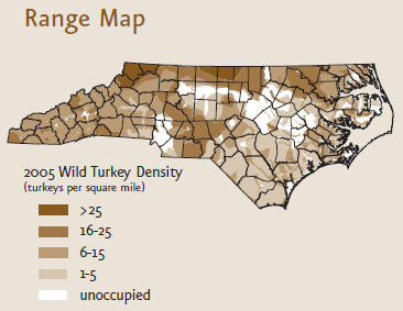
Here is a map of the wild Turkey population in North Carolina in 2005.
As you can see, the turkey population 7 years ago was pretty dense in northern Durham County, it only makes sense that they will continue to spread into viable habitat , which includes inside the city limits.
Here are some pics of Wild Turkeys
Instead of just eating Turkey, go out and look for wild Turkeys in your Durham County back yard.
Let us know where you have seen wild Turkeys in Durham and have a safe holiday period.


